A late-season cold snap is set to push overnight temperatures to near or below freezing across a broad stretch of the Inland Northwest, with the National Weather Service warning gardeners, growers and outdoor enthusiasts across the region to protect sensitive plants before Sunday morning.
Where and When the Frost Will Hit

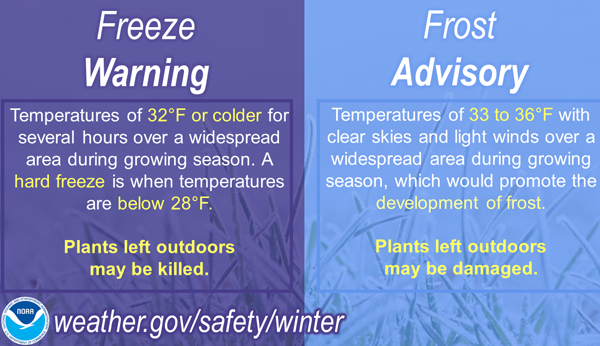
The National Weather Service office in Spokane issued a Frost Advisory in effect from 10 PM PDT Saturday through 11 AM PDT Sunday for five zones spanning Northeast Washington and the Northern Idaho Panhandle: the Northern Panhandle, Northeast Mountains, Okanogan Highlands, Okanogan Valley and Western Okanogan County.
Temperatures are forecast to drop to between 29 and 36 degrees overnight — cold enough to form frost across valley floors, mountain meadows and the high passes that characterize this rugged corner of the Pacific Northwest. The affected area includes well-known communities and recreation corridors: Sandpoint, Bonners Ferry and Priest River in Idaho; Winthrop, Twisp, Mazama and the Methow Valley in Washington; and the Okanogan region towns of Omak, Oroville and Tonasket.
Highway passes including Sherman Pass, Loup Loup Pass, Disautel Pass and the Highway 20 Wauconda Summit are all within the advisory zone — relevant for campers and travelers who may have gear out overnight.
A June Frost in a High-Elevation Region

Early June frost is not unusual in the mountains and valleys of Eastern Washington and North Idaho. The region’s elevation — much of the advisory area sits between 1,500 and 5,000 feet — keeps nighttime temperatures unpredictable well into summer.
The last spring frost date marks when it is generally safe to plant outdoors, but frost is still possible after that point, according to the Old Farmer’s Almanac frost date calculator, which advises gardeners to always monitor local forecasts rather than relying solely on average dates.
“Sensitive outdoor plants may be killed if left uncovered,” the Spokane weather office warned in the advisory — particularly relevant in the Methow Valley and Okanogan Highlands, where orchards, vineyards and market gardens are coming into their early-summer growing period.
Agricultural Stakes in the Okanogan and Panhandle

The Okanogan Valley and surrounding highlands are significant agricultural country. Washington’s Okanogan County produces a large share of the state’s apple, pear and cherry crop, and early summer cold snaps can damage blossoms and young fruit on trees that have already leafed out. The NWS Spokane office’s drought information reports have previously flagged the region as facing below-normal water supply conditions — meaning growers are already managing a difficult season before adding frost risk.
The Northern Idaho Panhandle, anchored by Sandpoint and Bonners Ferry, supports timber, hay and small-scale agriculture. At lower elevations in the Pend Oreille and Priest River valleys, tender vegetable crops and flowering annuals are the primary concern.
What to Do Before Saturday Night
Forecasters urged residents to take action now rather than waiting for the cold to arrive. Recommended steps include covering tender garden plants with row cover, frost cloth or even old bedsheets weighted at the edges; moving potted plants indoors or into a garage; and watering soil before nightfall — since moist soil retains heat better than dry ground.
For the latest forecast updates, check weather.gov/otx. The cold snap is expected to be brief, with temperatures recovering through Sunday morning as the advisory expires at 11 AM.